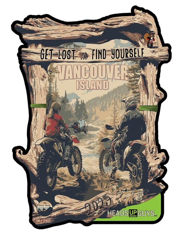
Skip to content

Gravel Routes

There's fsr's and railbeds everywhere!

In a region full of mountains and a thriving forestry industry, the Kootenays are just covered in Forest Serevice Roads and old mining tracks.

So, here’s how the maps works. Everything is based on the type of riding surface. Colour-coded for your convenience! Green is pavedBlue is unpaved, and Red is spicy! Spicy bits are unpaved but either more technical or has something on it that may be trickier for some rider/bike combinations. I’m never going to make assumptions about your skill level or enthusiasm, you know you. Always ride to what you’re comfortable with. 

There are waypoints for Camping, fuel, beer, motels, motorcycle shops, food, and cool places to see.

Get Lost – Find Yourself

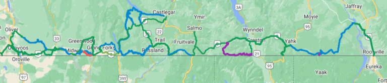
“Get Lost…Find Yourself” Adventure and Dualsport Motorcycle camping weekend. Critter Moto is excited to announce the first annual “Get Lost…Find Yourself” Adventure & Dualsport Motorcycle campout, taking place September 15-17, 2023 on beautiful northern Vancouver Island. This event is a charity fundraiser

Read More »

Darkwoods

What is Darkwoods? Well, its 63,000 Hectares of Conservation land just outside of Nelson. It’s a MASSIVE hunk of preserved wilderness, but lucky for us, there’s still some roads that go through it. It’s also known for the tiny community

Read More »

S2S Gold Rush – Nelson

the Sea to Sky is coming to Nelson!! Thursday ride from Sunshine Coast to Osoyoos (possibly through WA), stay at Osoyoos Hotel & Suites.Friday & Saturday stay at Baker Street Inn in Nelson.Sunday stay at Premier Best Western in Vernon.Monday

Read More »

Bulldogish

What’s Bulldogish? Well, for lack of a better name, it’s the network of roads and trails that wander around the Bulldog Tunnel. Encompassing a loose circle that includes Castlegar, Christina Lake, Grand Forks and Edgewood this area has a ton

Read More »

Yahk to Kikomun Rd

So you say you need a route to connect between Yack and Jaffery? Well, here it is! If you’re going between Creston and Fernie, or up into the Bull River, this is the way! The is a sneaky back way

Read More »
Map of Radium Motorcycle Routes

Radium

Welcome to Radium! There is so much amazing riding here to be had, both on and off-road. Here’s a selection of things you can ride, destinations to visit, and places to eat/drink/shop. Everything is rideable in either direction, and with

Read More »
Grand Forks BC is a destination hub for cruiser ADV and dual sport motorcycle adventures to ride paved and gravel routes.

Grand Forks

Welcome to Grand Forks!  Located just North of the US Border and is the gateway to the Granby, there is so much amazing riding here to be had, both on and off-road. Here’s a selection of things you can ride,

Read More »
Map of Revelstoke Motorcycle Routes

Revelstoke

Welcome to Revelstoke! There is so much amazing riding here to be had, both on and off-road. Here’s a selection of things you can ride, destinations to visit, and places to eat/drink/shop. Everything is rideable in either direction, and with

Read More »
Kaslo BC is a destination hub for cruiser ADV and dual sport motorcycle adventures to ride paved and gravel routes.

Kaslo

Welcome to Kaslo! There is so much amazing riding here to be had, both on and off-road. Here’s a selection of things you can ride, destinations to visit, and places to eat/drink/shop. Everything is rideable in either direction, and with

Read More »
Nelson BC is a destination hub for cruiser ADV and dual sport motorcycle adventures to ride paved and gravel routes.

Nelson

Welcome to Nelson! There is so much amazing riding here to be had, both on and off-road. Here’s a selection of things you can ride, destinations to visit, and places to eat/drink/shop. Everything is rideable in either direction, and with

Read More »
Kimberly BC is a destination hub for cruiser ADV and dual sport motorcycle adventures to ride paved and gravel routes.

Kimberly

Welcome to Kimberly!  A little bit of Bavaria tucked into the mountains of BC.  There is so much amazing riding here to be had, both on and off-road. Here’s a selection of things you can ride, destinations to visit, and

Read More »
Map of Trail Motorcycle Routes

Trail

Welcome to Trail! There is so much amazing riding here to be had, both on and off-road. Here’s a selection of things you can ride, destinations to visit, and places to eat/drink/shop. Everything is rideable in either direction, and with

Read More »
Nakusp BC is a destination hub for cruiser ADV and dual sport motorcycle adventures to ride paved and gravel routes.

Nakusp

Welcome to Nakusp! The village is a vibrant, safe and friendly lakeshore community nestled on the shores of Upper Arrow Lake in the West Kootenay region of British Columbia. It’s surrounded by the beautiful Selkirk and Monashee mountain ranges, natural

Read More »
Map of Trail Motorcycle Routes

Rossland

Welcome to Rossland! There is so much amazing riding here to be had, both on and off-road. Here’s a selection of things you can ride, destinations to visit, and places to eat/drink/shop. Everything is rideable in either direction, and with

Read More »
Map of Castlegar Motorcycle Routes

Castlegar

Welcome to the Castlegar! There is so much amazing riding here to be had, both on and off-road. Here’s a selection of things you can ride, destinations to visit, and places to eat/drink/shop. Everything is rideable in either direction, and

Read More »
Kimberly BC is a destination hub for cruiser ADV and dual sport motorcycle adventures to ride paved and gravel routes.

Cranbrook

Welcome to Cranbrook! There is so much amazing riding here to be had, both on and off-road. Here’s a selection of things you can ride, destinations to visit, and places to eat/drink/shop. Everything is rideable in either direction, and with

Read More »
Map of Invermere Motorcycle Routes

Invermere

Welcome to Invermere! There is so much amazing riding here to be had, both on and off-road. Here’s a selection of things you can ride, destinations to visit, and places to eat/drink/shop. Everything is rideable in either direction, and with

Read More »
Fernie BC is a destination hub for cruiser ADV and dual sport motorcycle adventures to ride paved and gravel routes.

Fernie

Welcome to Fernie! You’ll find a thriving cultural scene, the enthusiasm of a vibrant youthful population and a scenic, tranquil location in the heart of the Canadian Rocky Mountains. Located in south-eastern British Columbia, Canada (maps), Fernie is a 3-hour

Read More »
Map of Creston Valley Motorcycle Routes

Creston Valley

Welcome to the Creston Valley! There is so much amazing riding here to be had, both on and off-road. Here’s a selection of things you can ride, destinations to visit, and places to eat/drink/shop. Everything is rideable in either direction,

Read More »
Gaia map of the Kootenay Boundary motorcycle routes

Kootenay Boundary

It’s amazing how varied the terrain and communities are in the Kootenay Boundary region. You can travel through completely different environments all in the same day! And it’s all here to download in one PACK. Get the .gpx or .kml

Read More »

West Kootenays

So much amazingness in the West Kootenays to explore! Smooth, twisty roads and stellar backcounty. It’s all here to download in one PACK. Get the .gpx or .kml file via Gaia Gaia Tutorial on using files So, here’s how the

Read More »

Kootenay Rockies North

There sure is a heck of a lot to explore in the Kootenay Rockies North area!  Sooooo many jagged peaks and mountain streams…. Get the .gpx or .kml file via Gaia Gaia Tutorial on using files This area is the

Read More »
map of Moyie River FSR motorcycle route

Kid Creek / Moyie River FSR

A gravel shortcut from Kitchener to the North end of Moyie Lake! The Route follows the Kid Creek and Moyie River FSRs and cuts off a whole lot-0-slab! Get the .gpx or .kml file via Gaia Gaia Tutorial on using

Read More »
kootenay map of the works

The WORKS

You want the works? Well, here it is! All the tracks, routes, and waypoints in one place. No better way to see the big picture, everything in one view. Way easier to plan that next ride, so get at it!

Read More »
a map Granby Whatshan Edgewood shelter bay

Granby / Whatshan / Shelter Bay Route

Want a way to get from Grand Forks to the Shelter Bay ferry avoiding all that pavement through Nakusp? Have we got the answer for you! Stellar gravel riding through the Granby, Edgewood, Whatshan Lake and along the West shore

Read More »
map of lemon Creek motorcycle route

Lemon Creek Route

Heading up Six Mile Lake and down Lemon Creek is a classic dual-sport ride. The typical loop is just up, down and back on the highway through the Slocan Valley. But…..there’s options!! Get the .gpx or .kml file via Gaia

Read More »
map of kootenay lake tourism motorcycle routes

Kootenay Lake

Welcome to the Kootenay Lake Region! There is so much amazing riding here to be had, both on and off-road. Here’s a selection of things you can ride, destinations to visit, and places to eat/drink/shop. Everything is rideable in either

Read More »
map of Farnham Glacier Motorcycle route

Farnham Glacier

Just West of Radium is the hidden gem that is the Farnham Glacier. Easily accessed most of the way by FSR, the last little bit gets a little spicy! There is a creek crossing that although isn’t extreme, it’s not

Read More »
Map to show Canadian Border Patrol motorcycle route

Canadian Border Patrol

Welcome to the Canadian Border Patrol! Almost 400km stretching from Osoyous to Creston, travelling on as much dirt and backroads as possible. Rideable in either direction, and many points to hop on or off depending on what else you want

Read More »
Map of boundary Lake bypass motorcycle route

Boundary Lake Bypass Route

Here’s a sneaky and scenic little bypass to get you from the Kootenay Summit to Creston. It takes you along just North of the border and gives the opportunity to stop or camp at Boundary Lake rec site.  Get the

Read More »
Map of Koch Creek Pass Motorcycle Route

Koch Creek Pass

The trip up over Koch Creek Pass is a local classic. Can be used as as a fun shortcut between Fauquier Ferry and Highway 6 in the Slocan Valley. Get the .gpx or .kml file via Gaia Gaia Tutorial on

Read More »
Old Cascade Highway Map

Old Cascade Highway

Old Cascade Highway is a gravel road sightseeing highway exploring the switchbacks, trails and wilderness scenery in the Monashee Mountain Range. The scenic highway goes by many names such as the Old Cascade Highway, Santa Rosa Road and the Old

Read More »
Pend-d'oreille motorcycle route map

Pend-d’Oreille River route

The Pend Oreille River is a tributary of the Columbia River, approximately 130 miles long, in northern Idaho and northeastern Washington in the United States, as well as southeastern British Columbia in Canada. In its passage through British Columbia its

Read More »
map of Castlegar - Christina Lake motorcycle route

Castlegar-Christina Lake Route

Do you like beautiful Lake views? Do you like groomed railbed gravel? Do you like getting around a mountain pass on the pavement? Do you like old railway trestles? But….are you afraid of the dark? Bulldog tunnel is almost a

Read More »
map of trout lake motorcycle route

Trout Lake Loop

Discover the Kootenays on a breathtakingly picturesque circle motorcycle tour through the heart of the Selkirks, a 390-kilometre loop that starts and ends in Nelson, B.C., with stops in New Denver, Nakusp and Kaslo. Get the .gpx or .kml file

Read More »
a map of the Buchanan Lookout tower motorcycle route

Buchanan Lookout

The Buchanan Lookout stands tall at 1,912 m (6,272 Ft) and offers stunning views of the Kootenay Lake, Kokanee Glacier Provincial Park, Goat Range Provincial Park and the Purcell Mountains. Get the .gpx or .kml file via Gaia Gaia Tutorial

Read More »
map of the motorcycle and atv trail to Lavina Lookout

Lavina Lookout

With one of the most spectacular 360degree views anywhere, put this one on the list. Download the .gpx file Get the .gpx or .kml file Surface: 100% Gravel Distance: 12km  Access: Turn right on Argenta Road toward Argenta and Johnson?s

Read More »
a map of the Grey Creek Pass motorcycle route

Gray Creek Pass

The climb to Gray Creek Pass is 5,000 ft of elevation gain in 16.5 km making it the highest dirt pass in Canada! The 6,850 foot high Gray Creek Pass runs between Kootenay Lake on the west and Kimberly to

Read More »