
Kimberly


Welcome to Kimberly! A little bit of Bavaria tucked into the mountains of BC. There is so much amazing riding here to be had, both on and off-road. Here’s a selection of things you can ride, destinations to visit, and places to eat/drink/shop. Everything is rideable in either direction, and with many points to hop on or off depending on what else you want to do. Towns in this neck of BC are spread out, but there’s lots of opportunities for fuel, food, and lodging…
Ride Respectfully
The Kootenays are populated by mostly smaller communities that offer a relaxed pace. We all love this area and want to keep it our little, peaceful piece of heaven. If you’re going to ride, please Ride the the Road to Respect.
Riders Paradise
With winding roads boasting impressive scenery, the Kimberly is a must-ride destination for motorcycle touring, with some of the best motorcycling roads in BC. And the backcountry is incredible! There is a staggering amount of FSR’s that go through beautiful terrain.
Lots to see and do! Aside from the spectacular riding, the Kootenay region is just full of amazing things to experience. Not to mention the top-notch restaurants and cools shops. And when you need to rest up for the next day, there’s plenty of places to sleep.
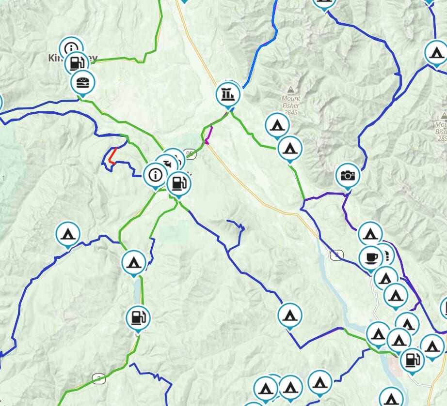
All the Routes and waypoints
⬇️ Get the .gpx or .kml file via Gaia Gaia Tutorial on using files
So, here’s how the maps works. Everything is based on the type of riding surface. Colour-coded for your convenience! Green is paved, Blue is unpaved, and Red is spicy! It’s unpaved but either more technical or has something on it that may be trickier for some rider/bike combinations. I’m never going to make assumptions about your skill level or enthusiasm, you know you. Always ride to what you’re comfortable with.
There are waypoints for Camping, fuel, beer, motels, motorcycle shops, food, and cool places to see.
You can add everything in Gaia to you own (free) account, or download it straight away and add it to any app or Garmin unit.

Ride the Routes

Granby / Whatshan / Shelter Bay Route
Want a way to get from Grand Forks to the Shelter Bay ferry avoiding all that pavement through Nakusp? Have we got the answer for you! Stellar gravel riding through the Granby, Edgewood, Whatshan Lake and along the West shore

Lemon Creek Route
Heading up Six Mile Lake and down Lemon Creek is a classic dual-sport ride. The typical loop is just up, down and back on the highway through the Slocan Valley. But…..there’s options!! Download the .KML Download the .GPX View in

Glacier Route
Riding the loop around the Kokanee Park is a must do! Travelling through Nelson, Balfour, Kaslo, New Denver and through the Slocan Valley. It has some of the most flowy twisties anywhere. Get the .gpx or .kml file via Gaia

BC Fuel Stations
It’s sorta one of those things. If you travel around, you need gas. And when you need it, you really need it! Here’s a map of places to get fuel. Is this EVERY station? Of course not. If you’re headed

Campsites
One awesome part of travelling in British Columbia is the abundance of Recreational Sites to camp at! I’m a camper. I’ve always been a camper. Awesome day rides are great, don’t get me wrong. But seeing the sun set behind

Kootenay Pass Loop Route
Ok folks, this one is a classic! A paved, smooth, flowy cruise, it takes the rider through some spectacular scenery. Along the North Shore of Kootenay lake, across the longest free ferry in the world, through the twisties on the

Castlegar-Christina Lake Route
Do you like beautiful Lake views? Do you like groomed railbed gravel? Do you like getting around a mountain pass on the pavement? Do you like old railway trestles? But….are you afraid of the dark? Bulldog tunnel is almost a

Trout Lake Loop
Discover the Kootenays on a breathtakingly picturesque circle motorcycle tour through the heart of the Selkirks, a 390-kilometre loop that starts and ends in Nelson, B.C., with stops in New Denver, Nakusp and Kaslo. Get the .gpx or .kml file

Buchanan Lookout
The Buchanan Lookout stands tall at 1,912 m (6,272 Ft) and offers stunning views of the Kootenay Lake, Kokanee Glacier Provincial Park, Goat Range Provincial Park and the Purcell Mountains. Get the .gpx or .kml file via Gaia Gaia Tutorial

Gray Creek Pass
The climb to Gray Creek Pass is 5,000 ft of elevation gain in 16.5 km making it the highest dirt pass in Canada! The 6,850 foot high Gray Creek Pass runs between Kootenay Lake on the west and Kimberly to