
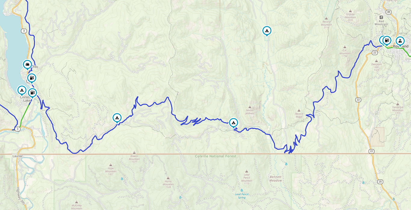
Old Cascade Highway

Old Cascade Highway is a gravel road sightseeing highway exploring the switchbacks, trails and wilderness scenery in the Monashee Mountain Range. The scenic highway goes by many names such as the Old Cascade Highway, Santa Rosa Road and the Old Cascade-Rossland Highway. The highway connects the community of Rossland, BC to Christina Lake.
⬇️ Get the .gpx or .kml file via Gaia Gaia Tutorial on using files
HOW THE MAP WORKS
The route is broken up into smaller tracks based on the type of riding surface. Colour-coded for your convenience! Green is paved, Blue is unpaved, and red is unpaved but either more technical or has something on it that may be trickier for some rider/bike combinations. I’m never going to make assumptions about your skill level or enthusiasm, you know you. Always ride to what you’re comfortable with.


Surface:
Gravel the entire route.
Distance:
62km: 2,500m vert gain/loss
Sevices:
None along route. Food and fuel in both Christina Lake and Rossland
Access:
Simple access right outside both towns.

Old Cascade Highway
The Old Cascade Highway is a historic transportation route which is the ultimate day trip through the mountains via a narrow, gravel road travelling over two mountain summits. The gravel highway route is popular for accessing mountain biking, hiking, dirt biking, atv-ing and horseback riding in the summer.
The highway road measures approximately 62 kilometres and is divided into three sections: the Cascade side, the middle and the Santa Rosa side. Closest to Rossland is the Cascade side. The highway road is a mixture of pavement and good gravel roads. The road contains many switchbacks while navigating up through forests and along mountain ridges leading to a summit and great views.
Closest to the community of Christina Lake is the Santa Rosa side of the gravel highway. The roads are rough, with loose gravel sections. There are switchbacks leading over big hills and through mountain valleys connecting to the Santa Rosa Summit and some great views. The best views on the Old Cascade Highway are found on the Christina Lake side, just before the summit.
There are no services on this highway. Be prepared and always ride with tools, a spare tube and water. Weather and temperature can change quickly in the mountains. Be prepared for flying rocks and dust clouds as the route sees a lot of traffic from all vehicle groups.
The Cascade Highway is also an access road to wilderness adventures. There are trailheads to some of the more popular hiking, backpacking and mountain biking trails in the region like the Seven Summits Trail and the Dewdney Trail.
 BC Ale Trail - West Kootenays
Rossland Beer Company
An award-winning nano-brewery tucked away in the Southwest kootenays. While Ryan Arnaud and Petri Raito ran a local U-Brew company called Trail Brewing they realized there was great demand for craft beer in their area. So the two best friends purchased a small nanobrewery system from a brewery in North
Read More » December 26, 2020 No Comments
Bonus Linkage

Get Lost, Find Yourself: 2025
August 25, 2025 No Comments
“Get Lost…Find Yourself” Adventure and Dualsport Motorcycle camping weekend. Welcome to the Third Annual “Get Lost…Find Yourself” Adventure & Dualsport Motorcycle campout, taking place on beautiful

Farnham Glacier
April 3, 2021 1 Comment
Just West of Radium is the hidden gem that is the Farnham Glacier. Easily accessed most of the way by FSR, the last little bit

Kaslo
December 22, 2021 No Comments
Welcome to Kaslo! There is so much amazing riding here to be had, both on and off-road. Here’s a selection of things you can ride,

The WORKS
May 25, 2021 4 Comments
You want the works? Well, here it is! All the tracks, routes, and waypoints in one place. No better way to see the big picture,

Nakusp
December 17, 2021 No Comments
Welcome to Nakusp! The village is a vibrant, safe and friendly lakeshore community nestled on the shores of Upper Arrow Lake in the West Kootenay

Kootenay Pass Loop Route
January 13, 2021 No Comments
Ok folks, this one is a classic! A paved, smooth, flowy cruise, it takes the rider through some spectacular scenery. Along the North Shore of