


Ride Report – The Invermere Excursion
With the last week of August upon us, the summer was quickly disappearing. After almost 4 months, MissVelocity’s broken leg was finally strong enough to

Boundary Lake Bypass Route
Here’s a sneaky and scenic little bypass to get you from the Kootenay Summit to Creston. It takes you along just North of the border
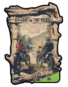
Get Lost, Find Yourself – 2025
“Get Lost…Find Yourself” Adventure and Dualsport Motorcycle camping weekend. Welcome to the Third Annual “Get Lost…Find Yourself” Adventure & Dualsport Motorcycle campout, taking place on beautiful

The WORKS
You want the works? Well, here it is! All the tracks, routes, and waypoints in one place. No better way to see the big picture,

Cranbrook
Welcome to Cranbrook! There is so much amazing riding here to be had, both on and off-road. Here’s a selection of things you can ride,

Gray Creek Pass
The climb to Gray Creek Pass is 5,000 ft of elevation gain in 16.5 km making it the highest dirt pass in Canada! The 6,850
What a great resource this is. Just subscribed to Gaia. Appreciate you sharing. Thank you?
Excellent job with all this. I downloaded The Works. I’m finishing up the IDBDR soon and plan to head into BC a little before turning back south on the Continental Divide Trail. Now I have some Canadian dirt to ride.
We can’t import more than 1 000 items in GAIA. Not sure how to import The Works 🙂
aaaahhhhhhh!!! I’ll have to split things up, gimmie a few days…